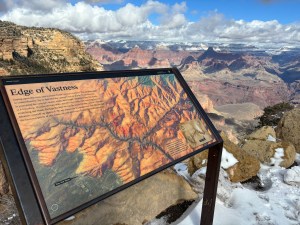
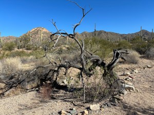
The first stop on my weekend of fun in Flagstaff was a stop at the Grand Canyon National Park. I’d never been, and it was overwhelming beautiful. The pictures don’t give you the sense of grandeur that you get on the Rim Trail. It was the most epic national park I’ve been to so far.
There was a bit of a winter storm the Friday before I left for Flagstaff, but they’re used to that sort of thing, so the roads were clear sailing, and the scenery was beautiful. In addition to the national parks, I also gotten to drive through many national forests, including the Coconino National Forest on the way to Flagstaff and then Kaibab. There was a bit of fog, too, which added to the mystic of the Saturday morning drive.
The parking lot at the Grand Canyon visitor’s center was covered with snow, so there was a lot of improvised parking. That turned out to be quite amusing when I left in the afternoon and the snow had melted. I think I ended up accidentally took up 3 parking spaces. Oops.
While I was in the park, I took one of the shuttles to the village area. I went to the restaurant in the Bright Angel hotel for lunch and had some pot roast, which was a delicious, warm treat on a cool day. They had a small museum with some history around the hotel, and I learned about Mary Colter who had designed many of the buildings still remaining in the Grand Canyon area and reminded me that I saw something she’d designed in Santa Fe as well.
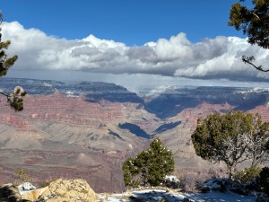
After lunch, I wandered around the village area and saw the Lookout Studio, Kolb Studio, Hopi House, and stepped into the Verkam Visitors Center. I took the South Rim trail to the Yavapai Point, which had numerous great views of the canyon. It was also paved, which was a great surprise. I also learned that my hiking shoes were on their last leg – at least for my old feet. 🍫🍫 Toward the end of the day, it slowed me down.
After my time at the park, I drove back down to Flagstaff and checked into my hotel. I had a great room, and I laid down to relax. Honestly, I was not feeling the best, and I couldn’t put my finger on why. I did look up altitude sickness, and I did have some of those symptoms. It seemed to pass after I took my nap, so I headed out to find something to eat. I ended up at a brewery (Dark Sky), and the food was good; the beer was fine.
On Sunday, I grabbed breakfast at a great spot – The Station Cafe and Lounge – and drove around Flagstaff to check out the library (where there was a quilt display and used books for sale), the university, and to find a place to inflate my tires. I also noticed that someone had taken the caps from my tire valve stems on two of my tires, so I stopped a bought some of those. It was surprisingly difficult to find a place to inflate my tires where the actual device worked. 🍫🍫🍫
Unplanned Adventure
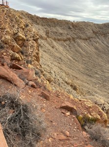
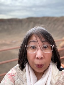
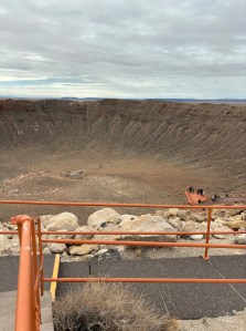
By midday, I was ready to do some more exploring, so I headed out to Winslow, AZ. On the way, I kept seeing signs for a giant meteor crater, so of course I stopped to see it. On my way out of that area, I did find a place to inflate my tires for free.
It was an amazingly large crater.
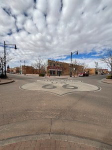
I had lunch at this beautiful hotel in Winslow, AZ. Where I had a lovely salad for lunch in the Turquoise Room and enjoyed a delicious glass of prickly pear lemonade, and they even gave me a to go cup for the road. Then, of course, I stood on the corner, and it was remarkable.
After a month of staying in one place, it almost felt like we were starting all over again when I fired up Estella and got on the road. I decided to leave ABQ a day early, so we could make a stop at Saguaro National Park outside of Tucson, AZ. This benefited us in two ways: we could take a southern route and possibly avoid some unsavory winter weather, and we could check another national park off our list.
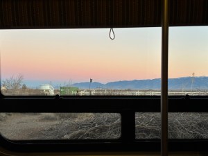
We took advantage of our Boondockers Welcome membership again and stayed at a ranch off the highway near Willcox, AZ. The sunrise (pic above) was beautiful, and the hosts were very kind and made time to visit about everything from schools to politics to AZ life. I am the type of person who likes to keep to myself, but I’ve tried to be open to impromptu conversations on this journey, and they have not been disappointing.
The next morning, we drove to Tucson and made a stop at a local bakery, La Estrella Bakery, on our way to Saguaro. The donuts and churros were fresh and delicious but – sadly – it wasn’t a tamale day.
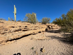
When we arrived at the Saguaro National Park, I was stuck by the sheer number of cacti. I caught another park ranger talk in the morning and met two women who were visiting the area from Lakeville, MN, where I used to teach – such a small world. The ranger was also a retiree from, you guessed it, Minnesota. We strolled around the garden area where he pointed out an abundant amount of information about the Saguaro cacti and other plant and animal life in the park. Did you know that the Saguaro cactus is about 60 years old before it starts to grow its first limb and that they are also self-healing?
After the ranger talk, I strolled around the visitor’s center and took some more pictures, and then we traveled out of the park toward Gilbert, AZ, our next stop. This was probably the warmest day that we’ve had so far on our adventure. The sun and the heat felt good after the colder temps we just left in NM.
Mishaps and Maps
A reminder of the Mishap Scale >>> (🍫 = minor; 🍫🍫 = ordinary; 🍫🍫🍫 = embarrassing; 🍫🍫🍫🍫 = terrible; 🍫🍫🍫🍫🍫 = not enough chocolate in the RV to recover)
We had only one real mishap on this travel day. While the bakery was delicious, the parking situation at the bakery was not. You’d be just fine in a car or truck or mini van, but in a 24′ van, it was a little hair-raising. In hindsight, I should’ve parked further away and walked a little bit to get there, but there was road construction near the bakery, and I misjudged the size of the parking area a bit. I was able to park without issue, but the leaving was another story. It was about a 10-point back-up, turn the wheel, go forward, back-up type situation. No damage to Estella or the bakery, but that chocolate-frosted donut tasted even better after we made it out unscathed. 🍫🍫🍫
On Friday night, after I traded rental cars, I drove down to Roswell, NM. It was a really easy 3-hour drive, and I arrived in time to grab a quick dinner at the alien-themed McDonald’s. There were aliens everywhere, but I didn’t get a chance to check them out because I had a plan. I did see this beautiful mural when I was going through the drive thru, which was a highlight of the pretty ordinary town, sprinkled with alien statues and decor.
The Plan
I had a pretty aggressive itinerary for the Saturday when I woke up in Roswell. First up, I was driving to Carlsbad Caverns National Park, which is about an hour and 40 minutes from Roswell. After that, I was going to make the 3 hour trek to White Sands National Park by 4:30PM, so I could go for a sunset stroll with a park ranger and other park visitors.
Carlsbad Caverns
I cannot even begin to describe how beautiful the drive was to get to the cavern itself. You turn into a little town with a gas station, some shops, and a hotel. Then you enter the park itself, and I was amazed at the topography of the park. I should’ve stopped to take some pictures, but – you know – the plan must be obeyed. By the time I got to the visitor’s center, I had about an hour before I needed to get on the road to White Sands.
So, I bought my annual national parks pass, and I took the elevator down to the caverns. I gotta say that I’m still coming to terms with the feeling of claustrophobia that creeps up on me when I have time to think about the small space I’m in. There’s a lot of time when you’re in an elevator, going over 700 feet down an elevator shaft that is partially under construction. Apparently, the ride is only a minute, but I have to tell you that it felt longer. If I ever go back, I’d plan for more time and hike down and back up again.
It’s really hard to capture the grandeur of the caverns, so these photos really don’t do it justice. The photo on the left is The Bell formation, and I don’t remember what the one on the right is. I did end up being able to walk all the different paths in the caverns and get some underground steps in. It surprised me how humid it was, and by the time I was done walking all the trails, I needed to shed a layer.
I did stop for a snack because they have a snack station in the cavern (!!), and I didn’t know if I would have time to stop for lunch. The gal who took my money told me about the recent weather that I might encounter on my journey to White Sands. It was really helpful get a preview of the road conditions from a local, and I did end up taking the most direct route to White Sands NP.
Lincoln National Forest
When I entered the forest from the east on US Highway 82, I wasn’t particularly impressed. It was nice, but it didn’t seem that remarkable – mostly desert and vegetation, but definitely not as impressive as the drive into Carlsbad Caverns NP. About a half hour or so in, there was some snow on the ground, which was really beautiful to see. There are were ranches and houses along the road, and it looked peaceful with the fresh snow and sunny skies. The forest wasn’t done surprising me.
I hit the most beautiful stretch of Lincoln National Forest when I approached Cloudcroft and after I left the town. I hope I can go back soon, but I’m also glad that I wasn’t driving Estella. Since I wasn’t expecting it, there were a couple white-knuckle moments that had my palms a little sweaty.
White Sands National Park
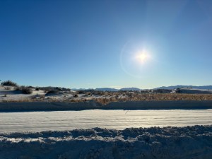
I was about 5 minutes early to the sunset walk at White Sands NP, and the drive through the park to the meet-up spot was remarkable. The park ranger, Sarah, was great. She shared that White Sands was one of the newest national parks – before it was designated as a national monument. Since it’s become a national park, more has been invested in the park, and they’ve made some incredible discoveries. We heard about wildlife, water sources, and the vegetation in the park, and we enjoyed a beautiful sunset.
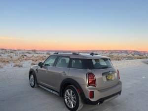
Just gorgeous views in all directions. That’s my adorable rental!! Take a close look at the ground clearance on that darling ride…more to come on that….
During our walk, I met a fellow traveler from San Francisco who was on her own adventure, meeting with a group she met through the Road Scholars. She was a delight, and it was really nice and encouraging. I did get on the road a bit later than I had anticipated, and it was definitely dark when I started trying to finding my way back to Albuquerque. Cue the mishaps after a mishap-free day….
Mishaps and Maps
A reminder of the Mishap Scale >>> (🍫 = minor; 🍫🍫 = ordinary; 🍫🍫🍫 = embarrassing; 🍫🍫🍫🍫 = terrible; 🍫🍫🍫🍫🍫 = not enough chocolate in the RV to recover)
I feel fortunate that, other than my heating issue, my travels have been fairly uneventful. The majority of this trip went to plan, which was a refreshing. I had done quite a bit of planning for the trip to get to my destinations and precious little planning for my return trip to Albuquerque. I had thought, “Just drop the address in the gps, and I’ll be back to Estella and Arthur in a few hours.”
It was about 20 minutes into the drive when I turned onto a very dark and unpopulated road. At the end of that road was a lovely gate with barbs and signs that said stop, turn around, and testing area. When I got back and Googled where I had been, it was a missile testing site. 🍫🍫 Pretty ordinary mistake to unwittingly trust that your GPS isn’t going to try to take you through a potentially hazardous road.
Crisis averted, and I made my way back toward the main road. I had stopped, looked at the actual map, and found the best way back to the highway via the lovely, non-missile laden Railroad Ave. Seemed harmless, and I was hungry. It was now pretty close to 7, and the last time I ate was around noon when I bought snacks at the cavern’s underground snack bar. I was ready for food, my rental car was ready for some fuel, and the road seemed like a perfectly lovely way to get to both.
I have no idea how long I drove on Railroad Avenue, but there were several signs along the road for “DIP”s in the road. Usually, these signs are a gentle warning and not a big deal, as dips happen. This road appeared to be the same – just small unevenness in the pavement.
I will say that I’ve noticed them more now after this one particular DIP incident, but there are occasional, short overpasses that you see in NM, where you could drive a car under, and I always thought they were curious but never knew what they were for.
I can tell you now that they are for water. On Railroad Avenue, I found a “DIP” that was more than just a bit of a bump in the road. I cannot explain to you how fast the moment went from driving on road to driving through water of what was likely Tularosa Creek. Remember the Mini Cooper from above? Not great for crossing creeks. I was shaken up, praying that I didn’t get water in the engine, or damage the rental, so instead of stop and take a picture of what we had just managed to muddle through together, I just kept driving. Once again, I was thankful that I wasn’t in Estella, that Arthur wasn’t with me, and that I had my wits about me enough to keep driving.
After I reached the main road again and found a gas station. I ate a corn dog, put gas in the rental, and said a prayer of thanks for getting to wherever I was and for that corn dog. 🍫🍫🍫🍫 I would’ve rated this one a 5-bar mishap, but there was, thankfully, enough chocolate in the van to ease my stress after that adventure.
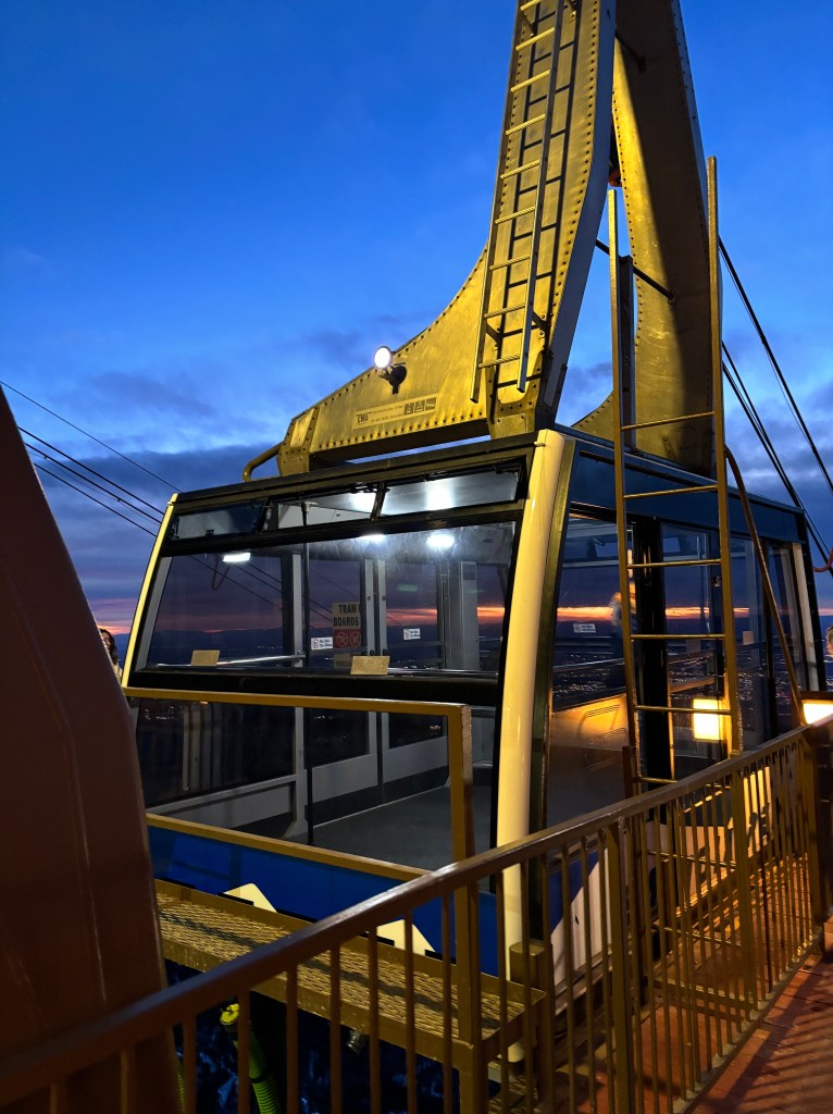
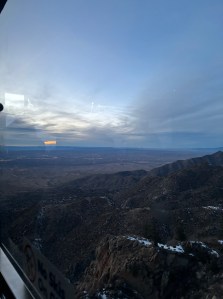
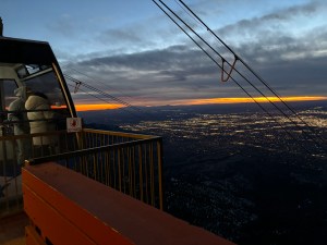
Disclaimer: I completely understand that it doesn’t make a lot of sense to get on a tram that hangs from some cables and makes its way up the side of a mountain (and swings a bit when you pass by one of the supporting towers) if you’re afraid of heights, but here we are, or there I was.
This is the tram I rode up and down the side of Sandia Peak after the New Year. Amazingly, it also carries hundreds of gallons of water to the top of the mountain to support the restaurant / bar – Ten 3 – that sits at the top of the peak.
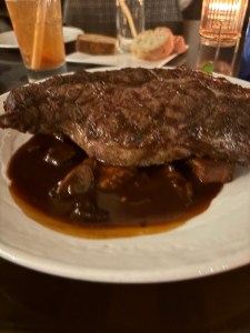
I can tell you that I felt relieved when we safely reached the end of the ride up, but I was still feeling nervous about the ride back down. I had made a reservation for dinner at Ten 3, and I thought a drink and some food might help assuage my fears a bit. Dinner was delicious; the ribeye steak was about as big as my face, so I happily left with leftovers.
I think the tram driver said we went from 6000 feet above sea level to 10000 feet above sea level. It makes my palms a little sweaty just looking at the pictures…
Safely on the ground again, I would say that it was a worthwhile experience, and I’m glad that I talked myself into it. I don’t think I would do it again.